Markkleeberg Weather station
Description
 |
|---|
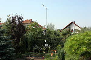
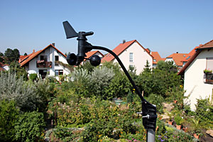
| Location owerview of the Markkleeberg weather station in the residential area Eulenberg |
The weather station is in the south of Leipzig in Markkleeberg (more precise in the residential area "Eulenberg"). In this way it lay in the Leipziger lowland bay - a landscape embossed from former opencast minings and arising lakes. Geographically it lies in 51°16.2' North and East 12°21.7' in a height of 125 m above sea-level.
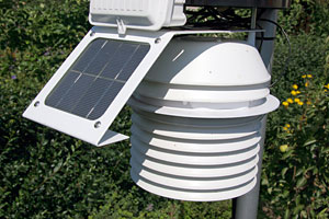
Measurement technology
 |
|---|
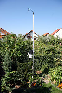
| Measurement pole with the sensors |
As measurement technology a radio weather station of the type "Vantage PRO2" of the company Davis is used. It consists of two transmitters: one basis transmitter (ISS) for the measured values temperature, humidity, precipitation, wind, radiation and UV as well as an additional station for soil temperature and humidity. The sensors are attached to a 5 m high measurement pole and/or buried under a lawn. The meteorological data are received by a monitor (Console) for displaying and in addition from a reception station (Envoy) for the transmission of the values to the PC. In both receivers sensors for the air pressure are contained.
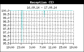
Reception quality
Because of the meteorological data are transferred by radio, it can result also in variations of the signal strength of the data. The data of the wind sensor which sends every 2.5 seconds are used for control.

Recieving devices
Console
 |
|---|
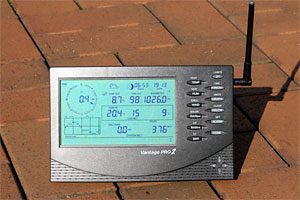
| As display of the meteorological data is used the Console |
For displaying the measured values and calculations is the Console of the Vantage PRO2 used. The LCD display measures 90 x 150 mm and indicates all current and recorded weather conditions and weather forecasts. In this case following measured values can be shown:
- Air temperature and humidity, dewpoint
- Barometric air pressure
- Wind direction and speed, wind chill (felt temperature)
- Sum of precipitation an rain rate
- Evapotranspiration for day, month and year
- Heat index, Temperature-humidity-sunshine-wind-index (THSW)
- Intensity of solar radiation, UV dose and UV index
- Soil temperature and wetness, leaf wetness
- Weather forecast, date & time, sunrise and sunset, moon phases
The measured values can be indicated graphically directly in the monitor unit. In this case more than 80 different evaluations are possible. More than 30 alarm functions with acoustic and graphic notification are possible.
With a symbol display with five different symbols and a running text with 40 different display texts the weather forecast is distributed.
The Console can obtain measurement data from up to eight different radio stations. A forwarding of the received data is possible. The high range between monitor and radio sensors is up to 250 m, it can be enlarged to 1.5 km by repeaters. A radio frequency is used to the transmission in this case by 868.35 MHz in the frequency hop spreading-procedure. The measuring cycle is (wind sensor) 2.5 seconds.
Weather-Envoy
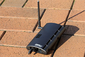 |
|---|
| The connection of the weather station with the computer is done through the Weather-Envoy |
The Weather-Envoy is an additional recieving station for the meteorological data and simultaneously a data logger. Thus the measured values can be stored (at a 5 minute measuring interval there is storage space for a week of data) and are read-out and processed with a PC.
Through a USB-connection the Envoy is connected with the computer. The software "WeatherLink" selects the data and prepares it for the Internet representation.
Additional an air pressure sensor is additional in the Weather-Envoy contained. This barometer has a measuring range of 880 to 1080 hPa at a solution of 0.1 hPa. The accuracy is indicated with +/- 1.7 hPa.
Sensores
Temperature and humidity
 |
|---|
| Temperature and humidity sensors in the weather hut |
At the measuring station different temperature sensors are used. The most important sensor for the measurement of the outside temperature is in an actively ventilated radiation protection case which is fortified approx. 2 m above ground at a pole. The sensor has a resolution of 0.1°C with an accuracy of 0.5°C in the measuring interval of -40 to +60°C.
The humidity is determined also in the actively ventilated weather hut. In the measuring range of 0 to 100 % the sensor can resolve the moisture on 1 %. The mistake is in this case at the most 3 %.
Air pressure
The barometer is not available as a individual sensor, but it is integrated directly into the Console and into the Weather-Envoy. It facilitates air pressure measurements of 880 to 1080 hPa with a resolution of 0.1 hPa and an accuracy of 1.7 hPa. In addition the air pressure tendency can be distributed through the software.
Precipitation
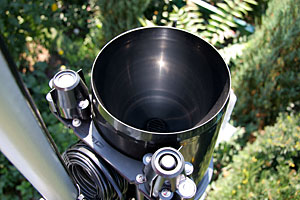 |
|---|
| Rain sensor with radiation and UV sensor |
The measurement of the precipitation occurs directly above the weather hut for temperature and humidity. The precipitation gauge has an absorbing-face of 200 cm² and can resolve in this way the precipitation exactly on 0.2 mm. As an accuracy 4 % of deviation are indicated. The measurement variable "rain rate" is in addition derived from the amount of precipitation per unit of time. So that in the winter at frost also the precipitation can be measured, a heating which holds the measuring system in a frost-proof way is built-in in the rain gauge.
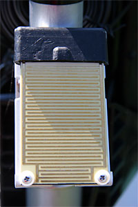 |
|---|
| Sensor for the measurement of the leaf wetness |
A good indicator if one is liked to know the time of the beginning of precipitation the leaf wetness. With a resistance measurement it is determined and indicates its beginning accordingly immediately after the start of the rain although the fallen amount is not measurable (because under 0.2 mm) yet. Of course not only falling precipitation in this way is measured, but condensed humidity, as fog. According to the humidity of the air water can deposit itself at leaves or other surfaces.
Wind
 |
|---|
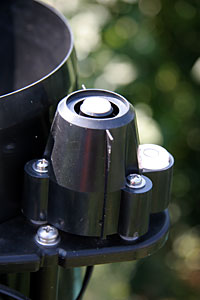
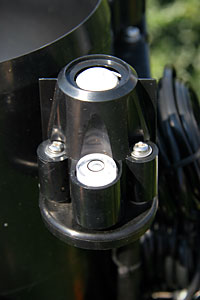
| Wind vane and cross arms for the measurement of the wind |
With two sensors the measurement of the wind happens: the wind direction is determined with a wind vane. It is around full 360° swivelling and can resolve the wind exactly on 1°. The mistake is in this case about 7°. Through the software one also can determine the main wind direction of a day. Also a compass rose with the corresponding denominationsexpressions like NO or SSW is representable.
The second measurement variable is the wind speed. It is measured with some cross arms. Maximally wind speeds can be measured with it by 54 m/s - this is almost 200 km/h. (Conversion: 1 m/s = 3,6 k.p.h.). The mistake of the speed measurements is described by more than 0.5 m/s with 1 m/s resolution. However, especially the wind speed is dependent on obstacles and the height above ground. The measurement occurs here in a level of 5 m (Precondition WMO: 10 m). In the northeast stands a higher building, which falsifies the values.
Radiation and UV
 |
|---|
| Sensor for the solar radiation |
 |
|---|
| UV sensor |
The sensor for the solar radiation can determine these exactly on 1 W/m². The accuracy is in this case about 5 % of maximum deviation. The measuring range of the sensor suits to between 0 and 1,600 W/m².
A second sensor determines the UV dose. It is indicated in the unit "MED". A MED (minimum erythema-effective dose) is the minimum radiation dose caused separated skin reddening on the sun-exposed skin face ("sunburn"), expressed in energy amount per face unit (J/m²). A MED at the human being corresponds to a UV radiant flux of about 200 J/m² at a wavelength of 297 nm. The measuring range of the sensor is from 0 up to 199 MEDs.
The UV sensor supplies one further measured value: the UV index. It is a measure of the intensity of the sunburn-effective ultra-violet radiation and is on a open scale represented. From experience it takes values between 0 and 8 in Germany, in extreme cases 9, in the higher levels of the alps also of values of 9 to 10. The station supplies the UV index exactly on 0.1 with a mistake of 8 %. When maximum value is 16.
Soil properties
 |
|---|
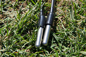
| Temperature sensores for the soil temperature |
Fot determing the soil properties there is a second radio station. With that three high-grade steel temperature sensors and two humidity sensors are connected. A temperature sensor measures the air temperature directly above the ground surface within a hedge protected against direct solar radiation. Two more temperature sensors are buried in 10 and 50 cm of depth under a lawn. The temperature sensors have a resolution of more than 1°C and a mistake of 0.5°C.
 |
|---|
| The determination of the soil wetness occurs with these humidity sensors |
For the determination of the soil humidity two soil wetness sensors are buried in 10 and 50 cm depth. Their measuring ranges suit to between 0 and 200 cb at a resolution of 1 cb. The higher the measured value is, the drier the soil is.
Further measurement variables
Besides the already mentioned values the weather station provides more variables. Besides the "normal" air temperature also temperature indexes are determined. These include the influence of other measurement variables into the calculation. For example the Wind chill temperature contains the cooling effect of the wind. The heat index includes the air humidity. THW and THSW index uses temperature, humidity, wind and latter also the solar radiation.
From the humidity of the air and the temperature the dewpoint is determined. The already mentioned rain rate is calculated from the intensity of the precipitation. The evapotranspiration - therefore the evaporation - calculates itself from temperature, humidity and wind.
A further calculated value is the air density.
Evaluation
 |
|---|
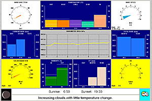
| The software "WeatherLink" is used for the evaluation and the processing of the mearesured values |
The recieving station Weather-Envoy has a built-in data logger, that can be connected via the USB interface with the PC. The software "WeatherLink" also a product of Davis is used for the read-out. The log interval of the data logger is every five minutes. WeatherLink transfers these measured values into the computer every 15 minutes. There the internet pages with the measuring datas, extreme and average values are refurbished and the suitable diagrams produced. Afterwards everything will be transfed to the Internet.
A second software, the "PC-Wetterstation" of Werner Krenn takes over an additional evaluation. Their data are added manually to the internet pages.
Camera
 |
|---|
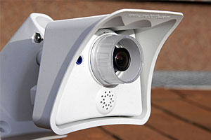
| The network camera produces every 15 minutes a picture of the current weather conditions |
As enlargement of the weather station serves the network camera of Mobotix. The model "M22M-Sec" may reach a resolution of 1280x960 pixel bei 10 pictures per second. Additionally a webserver is integrated in the camera, which can upload the images automatically to the Internet.
The weather webcam is directed to the North and with its 22 mm objective it photographs an area from Northwest to Northeast. Every 15 minuten a picture is taken.