Which weather is tomorrow like?
Preface
... this question is not supposed to be answered here directly. Rather some tips are supposed to be given, to be able to predict the weather itself. The following texts come from the booklet "Welches Wetter ist morgen?" from Hans Eder-Lohen published in the publishing house E. Nister in Nuremberg around 1920.
 |
|---|
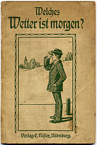
| The cover of the booklet |
Which weather is tomorrow like? So the farmer asks himself if he has to perform works in the open air, also every of you, that wants to do an excursion on the next day. The thing is not, very as simple as one usually thinks. The grandfather troubled from the rheumatism says certainly tomorrow rain weather is, because I notice it at my links. Often it applies, because the moist becoming air pleases the at rheumatism sufferers usual not. Mostly one can trust practised sailors if they predict the weather for the next day, because they have a fine power of observation for natural influences which they acquire by themselves. At the very least are the following farmer rules worth with an only exception that is right:
If the cock crows on the manure,
So the weather changes
Or it remains as it is.
This rule can serve us also little, for which we want to train ourselves even as weather prophet. Without some aids we will presumably not achieve this, because if we want to predict the weather for the next day, we must be able to make ourselves a precise picture of the respective air state so, we need several meteorological instruments at which at every time the air itself indicates clearly how its water content, its pressure, its temperature and its movement state is. We divide these instruments into heat measurers (thermometer), air pressure gauges (barometer), hygrometers (hygrometer) and wind measurers (anemometer). Through comparison of the mentioned instruments and precise permanent observation we can achieve a quite good result. It is very wrong if for instance we infer the change of the weather through rise and fall of a barometer alone. In the meteorological stations one has very fine instruments (main of W. Lambrecht in Goettingen) availably, for our purposes less fine instruments that we can build partially for ourselvesare enough.

Observation rules
Dewpoint rules
1. The higher the dewpoint of the current temperature, the more probably precipitations are to be expected.
2. The evening dewpoint is in the summer (6 o'clock in the evening) at most 4° lower than the 8 o'clock morning temperature, precipitaions are like this approaching.
3. If the evening dewpoint is deeper around 5-8°, good weather is like this in prospect.
4. Is the difference between evening dewpoint and morning temperature 6° and was the difference between the daytime temperature of already 1-2 hours just so large, good weather is even with unfavorable circumstances like this in prospect.
5. Is the dewpoint at the evening 0°, night frost is approaching.
Gerneral weather rules
Preliminary notes. Consequently the main observation serving for the weather prediction the next day for the is from April to the end of August at 6 o'clock, in the remaining time one hour in before sunset, in March and September at 5 o'clock, in February and October at 4 o'clock and in November, December and January at 3 o'clock. The measurement of the humidity is not supposed to be taken in immediate proximity of big rivers, lakes, ponds and swamps and deep forests.
 |
|---|
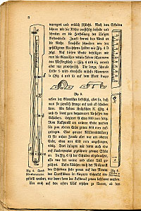
| A detailed description of the measuring instruments with rough drafts |
If before or during the observation precipitations fall, or if there is fog, and very especially if these already several days last, a withdrawal must be made like this by 5-15% of the found percent of the relative moisture according to the more or less strong wetness of the soilbecause of the too big soil humidity before the determination of the dewpoint because precipitaions would be predicted normally again and again. In the winter, when the soil in a very hard way did not freeze, we are supposed to bring 5% anyway into withdrawal.
With the prediction of the weather we must also observe the movement of the clouds. It can occur, that western winds blow below while the clouds are drifting to westwards. In this case we must do the prediction with the eastern winds.
In the case of continuous storm the barometer is mainly to be asked. The prediction does not become reliable again before it begins to climb permanently.
Fractions of a temperature degree are to be rounded off on the next integer, therefore less than 0.5 to the lower one and over 0.5 onto the nearest higher integer (for example 5.4° on 5° and 5.6° on 6°). The case is doubtful, at about 3.5° or 4.5°, so one must give the forecast of 3° and 4° or of 4° and 5° with mixed weather.
Weather rules
A. Dewpoint lower than the 8-clock morning temperature
a) Up to 2.5°C:
1. at eastern winds*): cloudy to semisunny weather, in the winter half-year mostly with strong – and when temperature is above 0° wetting fog. Precipitation only in case of barometer reading low or varying very much.
2. at western winds**): Precipitations (rain or snow), sky mainly clouded covered. The smaller difference between dewpoint and mean temperature, the more precipitations.
b) 2.5°-4°C:
1. at eastern winds: semisunny to sunny weater. In the winter often fog or haze. Weak precipitation only in the case of changing quickly or low barometer reading.
2. at western winds: semisunny to cloudy, inclination to weak precipitation in the case of low barometer reading.
c) 5°C:
1. eastern winds: mainly sunny weather without precipitation.
2. western winds: semisunny to sunny weather without precipitation.
d) 6°C:
1. at eastern winds: sunny weather.
2. at western winds: sunny weather.
e) 7°-8°C:
1. at eastern winds: sunny weather.
2. at western winds: semisunny to almost sunny weather with moderate winds and without precipitation.
f) 9°-10°C:
1. at eastern winds: sunny to semisunny weather. At strongly falling barometer less precipitaions.
2. at western winds: windy, semisunny, with strongly falling barometer reading liking to short precipitations.
g) 12°C and more:
1. at eastern winds: windy, semisunny, with strong falling barometer short precipitations.
2. at western winds: bei westlichen Winden: unstable, stormy, semisunny, with short but strong precipitations.
----------
*) Eastern winds from NO over O to nearly S
**) Western winds S over W to N including
 |
|---|
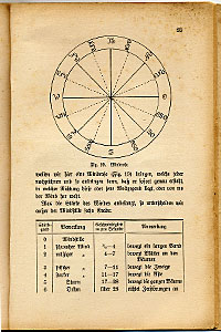
| The single weather elements as here the wind direction are declared too |
B. Dewpoint reaches the mean temperature of 8 o'clock in the morning or climbs over it, or +16.5° exceeds anyway
1. at eastern winds: sunny to semisunny weather, in the winter with fog and temporary coverage.
2. at western winds: thunderstorm. In the case of cool weather no thunderstorms, mostly only usual precipitation with increased temperature. If the dewpoint through longer time stopping almost or just around 6° lower is than the current temperature, so no thunderstorm, but mostly sunny weather with high temperature comes.
C. Dewpoint under 0°
1. at eastern winds: frost.
2. at western winds: frost.
D. Dewpoint highter than on the day before
1. at eastern winds: warmer weather.
2. at western winds: warmer weather.
E. Dewpoint lower than on the day before
1. at eastern winds: colder weather.
2. at western winds: colder weather.
F. The dewpoint moves from the 8 o'clock morning temperature or of the air temperature at the time of the observation around more than 8°
1. at eastern winds: more moderate, in the case of differences above 12° stiffen wind.
2. at western winds: strong wind, in the case of differences above 12° up to the storm growing. If the barometer falls, the wind climbs, climbs the barometer, so the wind reduces itself.